
Tom’s Thumb — Tom’s Thumb Trail
Tom’s Thumb is not a casual walk through preserved desert; it is a destination climb within the McDowell Sonoran Preserve. The trail leads deliberately upward into boulder fields and granite shelves before terminating beneath the Thumb itself—a massive, freestanding rock formation that feels geologic rather than scenic. This is one of the Preserve’s most physical routes, and its character is shaped by terrain first, views second.
For many North Scottsdale residents, Tom’s Thumb represents the line between everyday trail access and a purposeful mountain outing.
Route Intelligence & Physical Profile
The standard Tom’s Thumb Trail runs approximately 4.0 miles round trip (about 2.0 miles one way) with roughly 1,200–1,300 feet of elevation gain. The ascent is sustained and progressive, gaining most of its elevation in the final half of the climb.
Terrain transitions clearly as the trail rises. Lower sections are hard-packed decomposed granite and gravel, wide and engineered for durability. Higher up, the route narrows into rocky tread, embedded stone steps, and boulder-strewn sections, where footing becomes more deliberate and pace naturally slows.
There is no technical scrambling required to reach the official endpoint, but the upper trail demands balance and attention, especially on the descent when loose rock and fatigue intersect.
Difficulty
Tom’s Thumb is demanding due to elevation gain combined with distance, not because of technical obstacles. The climb is long enough to require pacing, and steep enough near the top to expose any misjudgment in effort or hydration.
The trail is fully exposed. Shade is essentially nonexistent beyond sparse desert vegetation, and reflected heat from granite becomes noticeable as elevation increases. This is a route where fitness and preparation matter more than ambition.
Water, Heat, and Timing
Water is mandatory year-round. The length of the trail, combined with exposure and late-stage elevation gain, makes dehydration a real risk even in cooler months.
During summer, use is heavily restricted to early mornings, and many locals avoid the trail entirely during peak heat. In winter and shoulder seasons, sunrise starts remain common to manage both temperature and trail traffic.
Parking & Trailhead Access
Tom’s Thumb is accessed via the Fraesfield Trailhead, located east of Alma School Parkway in North Scottsdale. The trailhead includes a large, well-organized parking lot, restrooms, and clear signage.
While parking capacity is better than urban trailheads, winter weekends and peak season mornings still see lots fill early. Unlike Camelback-area trails, overflow pressure on residential streets is limited due to preserve design and setback from housing.
Crowds & Use Patterns
Tom’s Thumb sees moderate to high use, but the distance and elevation naturally filter traffic. Casual walkers tend to turn around early, while committed hikers continue upward. This creates a more distributed experience than shorter, steeper city trails.
Crowds concentrate near the upper rock formation, where hikers pause longer and the terrain narrows. Even then, congestion is intermittent rather than constant.
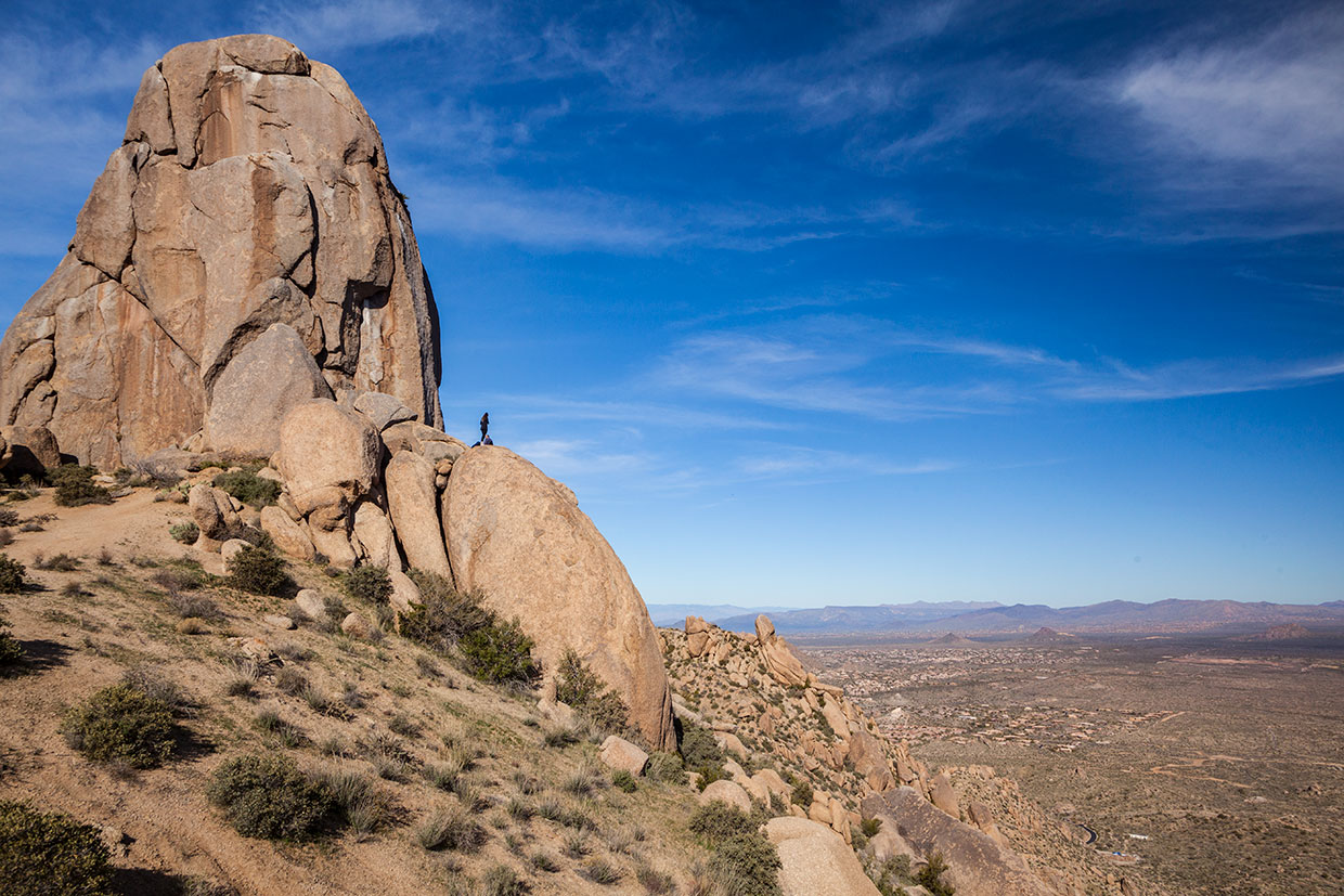
The Thumb & Upper Views
The trail terminates beneath Tom’s Thumb itself, an imposing granite monolith rising abruptly from the surrounding boulder field. The feature feels raw and geological, more reminiscent of alpine formations than typical desert landmarks.
From the upper sections and near the Thumb, views extend south and west over North Scottsdale’s planned communities, with the McDowell range unfolding behind you. This is not a single overlook moment; the visual payoff unfolds gradually as elevation is gained.
Preservation & Context
Tom’s Thumb lies fully within the McDowell Sonoran Preserve, and its access reflects Scottsdale’s preservation-first philosophy. Trails are engineered to withstand use without inviting off-route exploration, particularly in the sensitive upper boulder fields.
The endpoint is intentional. The Thumb is observed, not climbed, reinforcing the area’s emphasis on conservation over conquest.
Neighborhood & Real Estate Context (Critical)
Tom’s Thumb directly serves several of North Scottsdale’s most established desert communities:
- McDowell Mountain Ranch lies immediately southwest, with residents often treating Tom’s Thumb as a weekend or conditioning hike rather than a daily loop.
- DC Ranch sits south and west, where proximity allows access without crossing central Scottsdale corridors.
- Desert Mountain extends northward, and while many residents have internal trail systems, Tom’s Thumb offers a distinctly different terrain experience within a short drive.
- Silverleaf lies farther south; while not walkable, Tom’s Thumb functions as a nearby high-effort trail that complements Silverleaf’s internal open-space network.
- Sereno Canyon to the north
For buyers in these neighborhoods, Tom’s Thumb signals serious trail access—longer, steeper, and more physically engaging than Gateway or Pinnacle Peak, without the urban compression of Camelback.
Relationship to Nearby Amenities
Nearby golf includes Desert Mountain Club, Silverleaf Club, and DC Ranch Country Club. Dining and retail access remain concentrated along Scottsdale Road and within DC Ranch, keeping post-hike logistics simple without intruding on the preserve setting.